

Autumn Splendor And The 60th Parallel
Our Long Trek Through The Northwest Territories


60th Parallel to Hay River
Our first stop in Hay River was at the visitor centre. It was first rate with souvenirs, loads of information from a very pleasant lady, and outside there was a dump station and potable water filling ability.
Heading due north from the border on the MacKenzie Highway would take us through the whistle stop of Enterprise (consisting of a fuel station and truck repair shop), and on to the larger town of Hay River on the shores of Great Slave Lake. Of all the towns in NWT (including Yellowknife), Hay River was probably the nicest. Small enough to be personable, but large enough to have good services and something to look at and explore. The town’s visitor centre was first rate, and amazingly enough, still open. It was here that we got our first inkling of frustration about the early closing of tourist facilities and Territorial Parks in early September.
We couldn’t stay in the campground on the Hay River right when we entered the NWT, so for our fourth camp we opted for this spot on a nearby railroad access road.
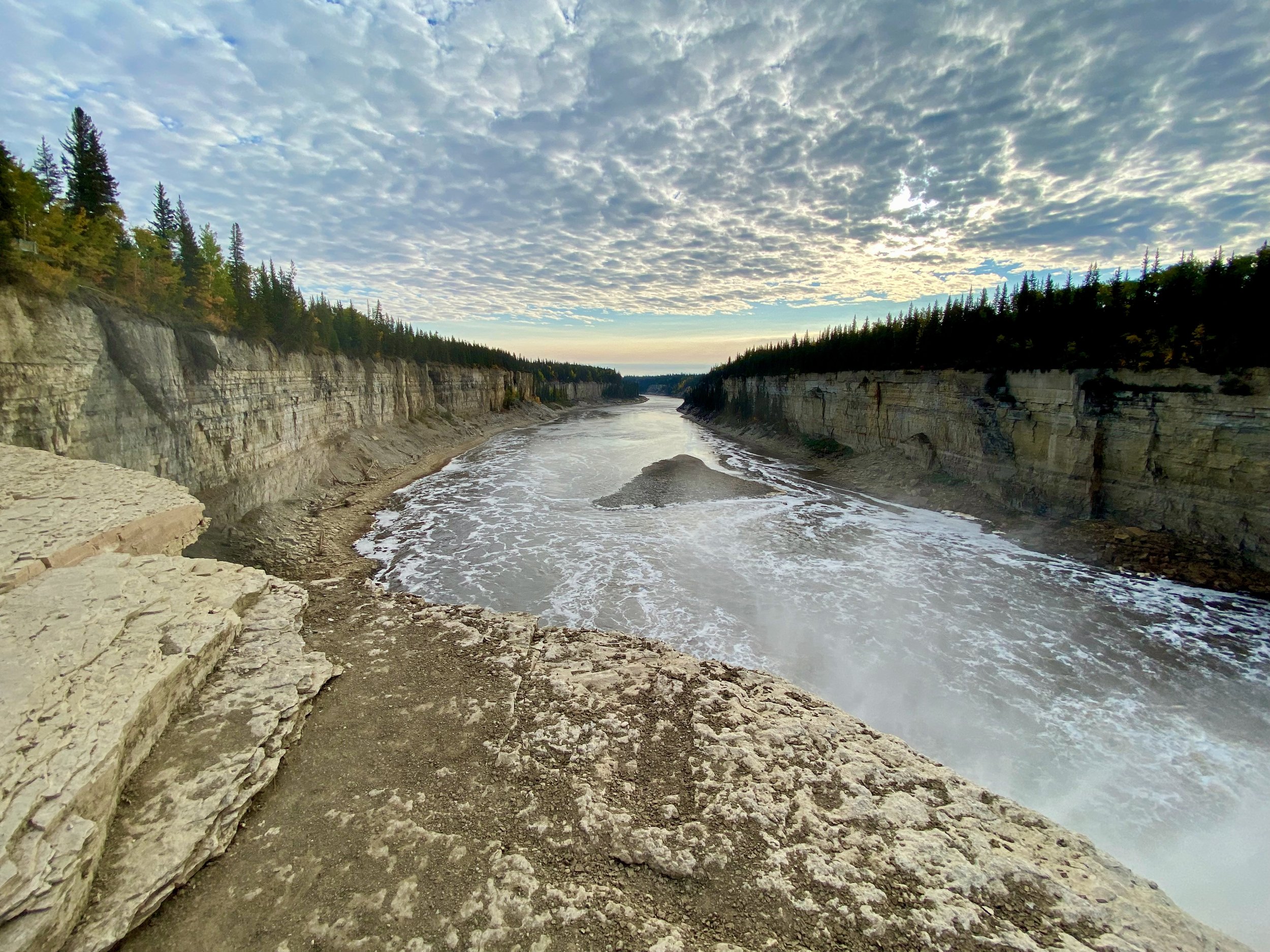
Since we arrived at the border around 4pm, and it was 120km to Hay River, we decided to look locally for a place to camp rather than try and drive all the way to the town. Fortunately, only a few kilometres down the road we found a side access road that was used for railroad maintenance, and tucked ourselves in there for the night. It was a good thing too, as the next morning we came upon what was probably the best natural feature we’d see in the NWT on this trip… the 30 meter high Alexandra Falls. Had we kept driving, we would have come to the falls too late in the day to explore it before darkness fell.
Alexandra Falls is one of two on the Hay River in close proximity to each other, but because of the Territorial closures, we were only able to see the one that was close to the highway.
The 30 metre tall Alexandra Falls on Hay River, NWT.


The Town Of Hay River
The vary impressive artwork displayed in the visitor centre parking lot. A giant collage made up of individually created tiles, each with their own tiny scenes.
The drive from the falls to Hay River was short, and we arrived in town early in the day. Our first stop, as always, was the visitor centre. There we were provided with a wealth of information, potable water for the truck, and even a few souvenirs of the town. All in all, a very good experience.
From the tourist centre we continued through the town and on to the harbour and the shores of Great Slave Lake.
At the harbour we met a very pleasant man by the name of Randy Froese who rolled up in a Hay River municipal vehicle, and got out to talk to us about our truck. Although we’ve had this kind of experience on many occasions, the difference in this case was that, aside from being keenly interested in our truck, he was a wealth of knowledge about the town and area in general, and very happy to share it. His family had been in the area for decades, and had a fly in fishing camp some miles up the lake. We spent some time talking with him about a number of different topics, and over the course of the next several days bumped into him around town on a number of occasions where he always took the time to come over and say hello.


Hay River To Fort Smith


We actually pass two signs like this, as we enter the park for a short spell, and then exit it again before reaching Fort Smith. Then as we head south from Fort Smith we once again enter the park. But this time we’ve reached the main body of Wood Buffalo National Park.
Having seen most of Hay River in the same day that we arrived, we elected to head out of town toward Wood Buffalo National Park. Although it was now mid-afternoon, we knew we’d be able to put some kilometres behind us before finding a camp spot somewhere along the highway.
The scenery alongside the highway was, for the most part, pretty uninspiring. On either side of the highway were forests of short, thin conifer trees interspersed with golden deciduous trees. But because it was such flat terrain, we couldn’t see past the trees at the edge of the road. The only time it got interesting was when there were pull-off points with informational signs, or we came upon a bison ambling along the road. And make no mistake about it, it was his road!
Reaching weights of over 1000kg. (2,200lb.), these animals know they have a commanding presence. If they don’t feel like moving out of the way, they don’t. It’s just that simple.
Even disused gravel pits can be pretty when there’s fall colour and a setting sun providing the well known Golden Hour.
After ambling along at a rather relaxed pace, seeing very few automobiles but a rather decent amount of Wood Bison along the roadway in several locations, the day started to get long in the tooth, so we started looking for a spot to camp. We pulled off on several side roads that looked promising, but yielded nothing of interest until be worked our way down a longer side road into a large clearing that must have been a gravel yard and equipment staging area left over from when the highway was built. It was very large, but well on its way to being reclaimed by nature, so we found a level spot and just after 6pm called it a day. As a precaution when wild camping in such dry conditions, whenever we pull off and park we always get out and look under the truck to ensure there is no vegetation near or touching our very hot diesel particulate filter and exhaust system. The last thing we’d want to do is start a wildfire where we were right at the epicentre.
The clouds rolled in overnight and in the morning we woke to our second short stretch of wet weather. Half an hour after we started rolling down the highway to Fort Smith, however, the rain stopped and never came back until we hit the very top of northern British Columbia. That rain spell also only lasted a part day, but was also accompanied by snow flakes.


Fort Smith & Wood Buffalo National Park


Fort Smith was one sleepy hamlet. Sure it was a Saturday, but here just about everything was closed for business. Of course the impressive government building that housed the Wood Buffalo National Park visitor centre was also closed up tight. So no help for us. That, along with the dreary weather put a damper on our spirits in a big way. So after spending a very short time driving around the town, we stopped in the parking lot of a closed auto parts store, answered a few emails and made a phone call while we had cell service, and then grudgingly headed out of town toward the park.


Wood Buffalo is also a Regional Municipality as well as a National Park, and it is this municipality that builds the ice road each winter from Peace Point, where the all season road ends, to Fort Chipewyan on Lake Athabaska.
The scene at the picnic ground a short way into the park. This is where we lowered our tire pressure for a smoother ride on the gravel road.
Hoping for better things to come, we set off from Fort Smith in the southerly direction and the gates of Wood Buffalo National Park. Our second entry to this park was as understated as our first. A sign or two on the road. Unlike most national parks that have a real gate with kiosk buildings and people checking to see that you have your purchased park pass, there was nothing of that kind here. The number of visitors to this park each year was probably so small that it wasn't worth spending the money on the entrance infrastructure. All that was there to welcome us was the open road with no one but us to drive on it. At least that’s the way it was most of the time. In driving the entire distance from the park entry to Peace Point at the end of the road, and back, we probably saw five other vehicles in total. Although most of the driving was down the road with trees on both sides only a few metres away, there was the odd scene from time to time that made the drive seem more worthwhile.


