

The Grand Canyon North Rim
May, 2013
The Arizona Strip Adventure, Arizona
Just after the turn of the year, a friend and AZLRO member/executive began talking about traveling along the north rim of the grand canyon, all off road. And so began the planning of a trip that would take place the following May, after the snows from the winter had completely melted.
Doug Lawyer's plan was to invite a select group of people to join us on the trip, ones that were sure to appreciate the splendor of the scenery, and the camaraderie of the company. Some were members of the Arizona Land Rover Owners club, some were from the Texas Land Rover club, and a few were just good friends that had a love of all things Land Rover.
Our group at Toroweep, north side, western end of the Grand Canyon. Photo by Doug Lawyer.
The next few months saw Doug doing most of the work figuring out the route of the offroad journey, and I helped with some of the GPS plotting. When May finally rolled around we were all set to meet up in Flagstaff, AZ to get the adventure on its way.
We had already set up our rig in Mormon Lake in anticipation of the upcoming Overland Expo event, so our trip to Flagstaff was a short half hour drive. Once at the local Safeway grocery store, we only had to wait a few minutes before the rest of the group started to arrive. Their first order of business... coffee!
The Journey Begins
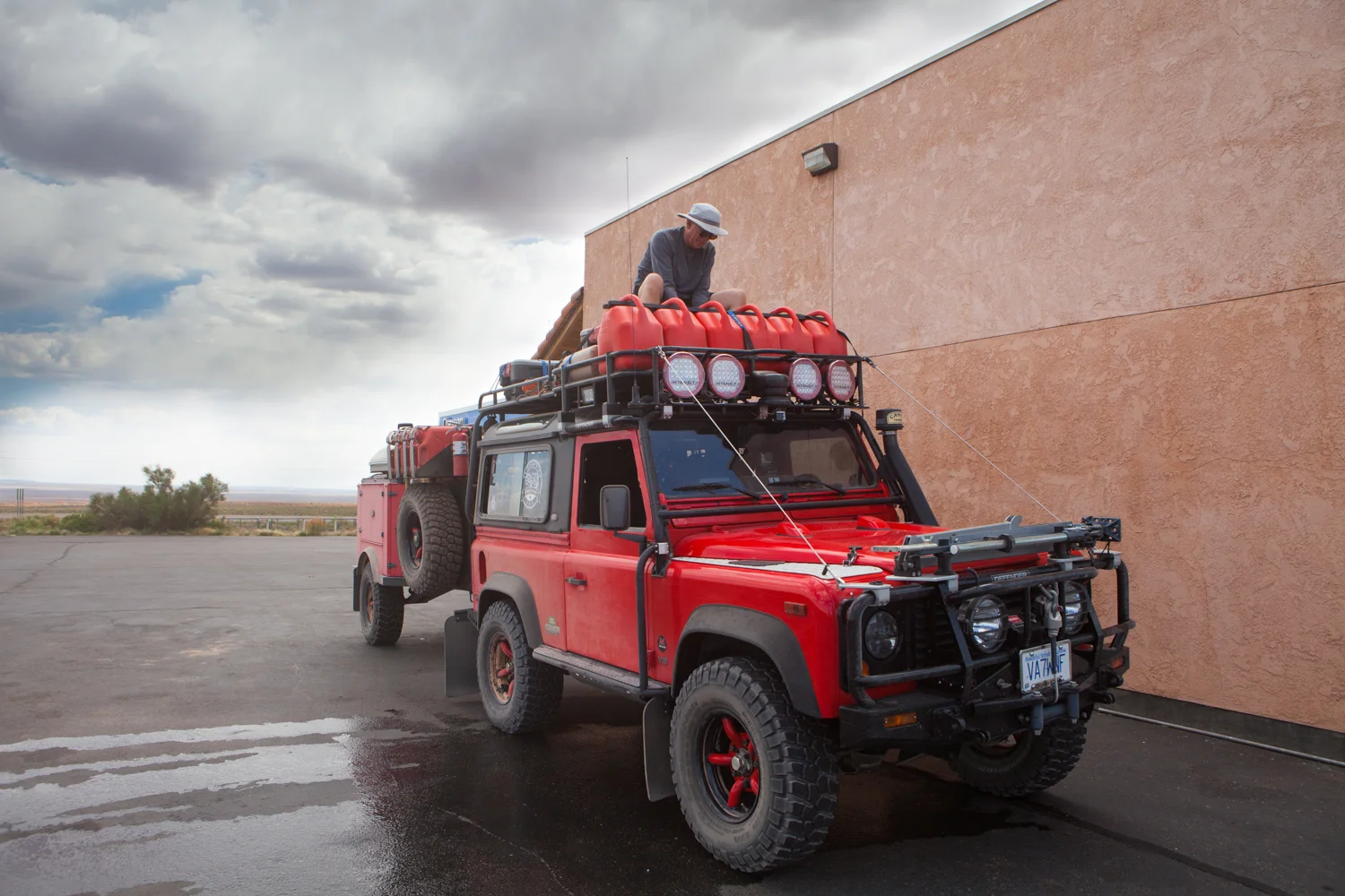
Since most of the group had traveled some distance to reach Flagstaff, many were low on fuel. This was remedied at a gas station on the north end of town, just as we were leaving civilization, so to speak. Since we had filled up our little red truck upon coming into Flagstaff, we were already good to go.
The road ahead would eventually lead us to Fredonia, AZ, some four and a half hours away. Although the travel time to get there is generally just over three hours, because several of the vehicles in the convoy were underpowered and heavily laden, covering the distance took longer.


Under normal circumstances, most of today's average automobiles would have been able to make the entire distance on one tank of gas. But in our situation, the Land Rovers with smaller tanks, like our Defender, would have to stop at least once for fuel. Although we all carried extra fuel containers for the off-road portion of the trip, we wouldn't be filling these until we got to Fredonia. Otherwise we'd just be burning extra fuel to carry extra fuel. So our refuelling pit stop along the way would be Jacobs Lake.


The Asphalt ends & the trail begins
First order of business… air down the tires so we get a more comfortable ride.
With our vehicle tanks and jerry cans full, we travelled the last few kilometres to the trail head. In this case, the trail head was initially a really good gravel road. But with the recent hot weather and lack of rain, this road was a dust nightmare for everyone except the person at the head of the line.


When this happens, all that can be done is to widen the spacing between the vehicles in the hopes that the dust dissipates as the next vehicle comes along. But sometimes we get lucky and nature lends a helping had. Strong cross winds will blow the dust sideways and out of the path of the following vehicle.
Eventually we came across an encouraging site, the first of the National Park boundary markers. From this point on we would have to abide by the rules of the park, as opposed to those of BLM land which are much less restrictive. What we failed to foresee was that wild camping in the National Park required a special permit, which we of course failed to get. We were lucky the first night as we were fortunate to be in an area without other people, and most importantly, without park rangers.


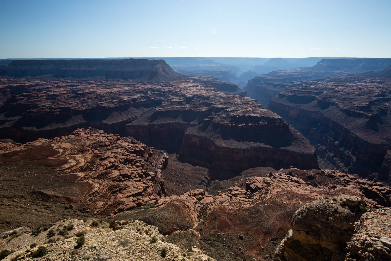
Kanab Point
After travelling some forty miles, and making the odd wrong turn, we finally arrived at the first nights stop. Kanab Point is situated right on the very edge of the north rim side of the canyon. The view was absolutely amazing. But since we were quickly losing daylight, we needed to leave sightseeing until the morning in order that we could get the camp set up for the night. But we had to take just a bit of time to enjoy what nature was showing us.


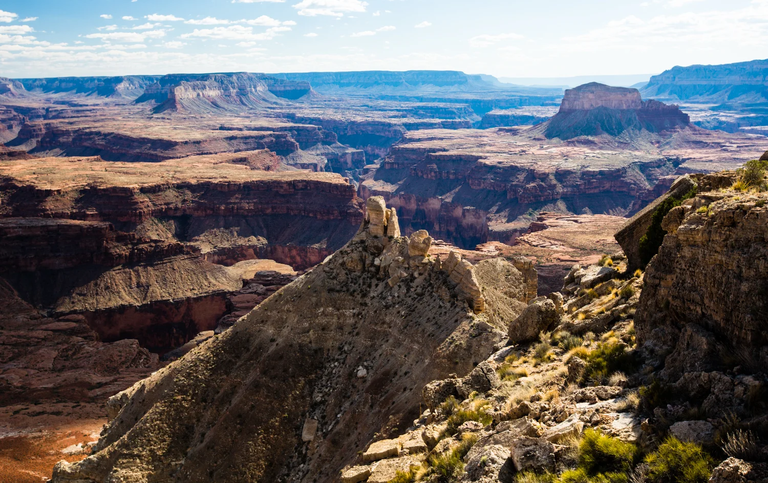
What was waiting for us the next morning, especially if we were eager enough to get up as the sun started peeking above the horizon, was nothing short of spectacular. With each passing minute, new features were highlighted as the sun's rays touched them. Truly a photographers paradise.


Although I was eager enough, or perhaps dumb enough, to get out of bed early, the rest of the camp residents took a more leisurely approach to canyon life. In other words, get up around 9:00 am and make coffee, then breakfast. After that was some lazy time sitting and soaking up the sun's warm, and discussing what's important. You know, Land Rovers.


SB Point… sort of
After our camp at Kanab Point was all packed up, and we were sure that any signs of our presence were gone, we started to make our way over to the next location on our itinerary, SB Point.
Although it was cool overnight, the day started to heat up early on. Fortunately, the temperature in the area where we were travelling at the time remained comfortable. Something we appreciated when we were sitting still, trying to figure out which way to go.


One of the problems of planning a route using satellite photos and google mapping is that often the path you think is the right one turns out to have issues that prohibits travelling on it. In the case of trails in the desert, especially areas used by ranchers, barbed wire fencing doesn't show up in satellite images and can block the way when you finally get there. As well as this, damage to a track can happen at any time due to heavy rains and flash floods, and this also may not show up on satellite images if sufficient time has elapsed from when the images were recorded. What this means is that there is a certain amount of trial and error when driving off road like this, and we had our share of it on this trip.
If you look closely at this map, you will see all sorts of fine lines running all about. These are tracks that exist, or did exist at some point, but might no longer be passable. No way to tell.
On our trek over to SB Point, which was our planned campsite for the next night, we had a few redirects. An on one we made it out to a point on the canyon rim that we hadn't planned. The reward, however, was more fantastic scenery. When we finally got to SB Point, it didn't disappoint. Well, the scenery didn't at least. But there was a problem...


Volunteer Park Rangers, a roving nightmare on two wheels
After spending some time at SB Point admiring the view, we started thinking about setting up camp for the night. What we didn't anticipate was the volunteer park "ranger" that was driving all over the place on his motorcycle trail bike. His job, he said, was to ensure that no one camped anywhere without a proper permit. And since we didn't have said permit, he made it his job to ensure we didn't stay at SB Point. There was discussion of waiting him out, hoping he would call it a day and we could just stay. But then we thought better of it. We had to leave the park boundary in order to camp, and this meant leaving the beauty of the canyon for the scrub of the non-park ranch land. A step down in accommodation to be sure, but no pesky wanna be rangers. Unfortunately, this dirt bike riding pain in the ass would rear his ugly head again, and spoil more legitimate camping as well. More on that later.


Heading to Toroweep
The next morning we started making our way over to Toroweep. There is a public campground there that we intended on using. It would be legitimate, as we wouldn't need a special permit to camp there.
This part of the drive was easy as we were now proper gravel roads more typical of national parks, instead of dirt tracks created by who knows who. But it was very dusty because of the lack of rain. Something we were used to, especially now that we seemed to have been relegated to the back of the group. This came about the night before when the rest of the group wanted to get to a camping area as fast as they could. We couldn't move as fast since we were towing a trailer.


Improper, unfair Profiling
As we got close to the Tuweep area, we stopped for a spell to discuss amongst the group what we would like to do. We all agreed we'd go and stay in the Tuweep Campground. But just as we were about to head over there, that same guy on the trail bike came along again and said he had been keeping an eye on us, and that if we were going to the campground, he had already warned the ranger that we were travelling as a big group (we don't consider nine vehicles as big).


When we arrived at the ranger station to check in for the campground, the ranger said the group camping was reserved and we couldn't go in. We said we didn't want the group site, but just wanted to stay in individual sites. He still refused us entry claiming that large groups like ours are always rowdy and cause damage. Right, a group of Land Rover enthusiasts, half were middle aged, three were seniors, and a few in their early thirties, were rowdy. Not likely we explained, but it didn't matter. The young ranger was insistent that we couldn't use the campground and would have to go back to BLM land and camp there. Oh, and when we came back to view the overlook, we'd have to all pile into only two or three cars and leave the rest behind. A difficult thing considering all the cars were full of kit.
Heading from the ranger station to the campground. The very empty campground.
After voicing our displeasure at the entire incident, including the guy on the motorcycle and his interference with our camping plans, we left. Once finding a wild campsite, I relayed my concern about leaving our vehicle, its kit, and all my photographic gear behind, unattended, while going to the overlook. So Doug suggested that Wendy and I go back to the park campsite on our own and set up there. Surely the ranger couldn't refuse us coming in by ourselves. So that's what we did. We felt bad about leaving the group, but it was the smart thing to do.
The empty campground
What upset us so much about abandoning our friends was that once we got into the actual campsite, it was mostly empty. It could easily have accommodated all our vehicles set up in individual sites, and had tons left over for other campers. So not only did this ranger and his roving ranger wanna be deprive considerate, nature loving campers of a decent campsite to rest in, they also deprived the National Park Service of some much needed tourist revenue in the way of campsite fees.


When we eventually returned to our rig at the Overland Expo, we just happened to have a couple set up camp beside us that worked as a ranger for the National Park Service, and were stationed at the main Grand Canyon office. We learned from them that the ranger at the Toroweep ranger station was a young, inexperienced guy who had heard of a problem at that campsite many years ago, and was terrified of having it happen again. So he refuses everyone that is not travelling alone.
Unfortunately, as it was of no use now, but this temporary neighbour of ours at the expo was the senior national park ranger in the area, and can override the other rangers. He gave us his contact info, and said that if we ever had problems again when travelling in the Nation Park Service areas, we could call him and he would sort things out for us. Nice to have info, but too late to help us at Toroweep.
We set up our camp in this site. Around behind the big rock on the right is the group campsite. No one was there. And the nearest camper to us was 100 yards away.
The Toroweep overlook
After we got set up at the campground we grabbed the camera gear, jumped in the Defender, and drove the short distance to the overlook. Perched some 3000 feet above the Colorado River, we could stand literally on the precipice and look straight down into the gorge, at the river. Certainly not a very safe place, especially for kids, pets or those suffering from vertigo. Unlike the south side of the canyon, where most of the tourists go, there was no fencing or railing to keep you from falling over. Perfect, unspoiled nature at its best!
Presently, the rest of the groups company arrived at the overlook, along with a few other sightseers. Some time was spent enjoying the view, getting photos of oneself in front of the panorama, and even some clowning around. We stayed until the sun was getting low, and the others had to make their way back to their wild campsite before it got dark.


Parting of the ways
After spending a quiet night by ourselves at the Tuweep Campground, we met up with the rest of the group at their wild campsite before beginning the day's trek. The plan was to follow the road west from where they were camped.
We did try several time to find a trail that didn't terminate at a dead end, but after this proved fruitless, it was decided to go back to a main trail and redirect after that. The GPS showed a more substantial route over to another major overlook some distance to the west, and it was decided that the group would try and make it there for the next night.
Unfortunately for Wendy and me, continuing further on the journey was becoming problematic. I was still recovering somewhat from abdominal surgery that I had five months earlier, and all the bouncing around off-road was started to elevate the discomfort level for me. Since we were at a point where there was an easy forty mile straight shot back out to the paved highway, on a wide gravel road, we said our good-byes to our comrades and headed back to Mormon Lake, and the comfort of our motorhome. The others would catch up with us there a few days later when they'd arrive for the Overland Expo.


The Journey Home…AKA Overland Expo
After pulling in at a fuel stop near Fredonia, and transferring some of the fuel from the jerry cans on the roof into the Defender's fuel tank, we began the long ride home. We'd probably make a couple of stops for more fuel transfer along the way, and we decided we'd stop at Jacob Lake for dinner and to look for a souvenir of the trip.


At Jacob Lake we had to make a decision about either stopping there and spending the night, or continuing on and driving into the night to get back to Mormon lake around nine o'clock. With the incentive of a comfy king size bed waiting for us back at the rig, we opted to keep driving. We made one last fuel transfer stop just south of where Highway 89A joins Highway 89, and then made the last leg of the journey back to the rig.
Taking a break after cleaning some of the dust out from inside the Defender.